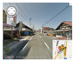
 On March 11, 2011 a magnitude 9.0 earthquake struck off the coast of Japan, but despite the extremely high intensity of the tremor itself, it was the resulting tsunami that caused the real damage. Most notable, and scary, was the meltdown of three reactors at the Fukishima nuclear plant.
Now, two years after the tragedy that cost more than 15,000 people their lives, Google Maps, through Street View, takes users back into the teeth of this disaster.
The search giant began this initiative shortly after the earth settled down, but now is updating its imagery. "Today we are updating the Street View imagery for 17 cities within the Iwate and Miyagi Prefectures for the first time since we published the first panoramas back in 2011. By releasing this new imagery on Google Maps, we hope people in Japan and from all around the world can virtually explore what these towns currently look like and better understand how local governments are working on rebuilding residents’ homes and lives", says Kei Kawai, Group Product Manager at Street View.
The company is not replacing the old imagery -- that will still be available to customers for the sake of historical value. "Starting today, people will be able to see 360-degree images of what these cities within the Tohoku region looked like before the tsunami and right after the tsunami, as well as what they look like today", the company announces.
In addition to that, the search giant is now publishing imagery of new areas within the Fukushima Exclusion Zone, including the abandoned towns Ōkuma and Futaba. This includes roads near the Fukushima Daiichi Nuclear Plant, and in the new imagery, users can even see the entrance to the plant on Google Street View.
These are powerful and emotional images, but kudos to Google for doing this for the people of a nation that has been hit hard with this tragedy.

